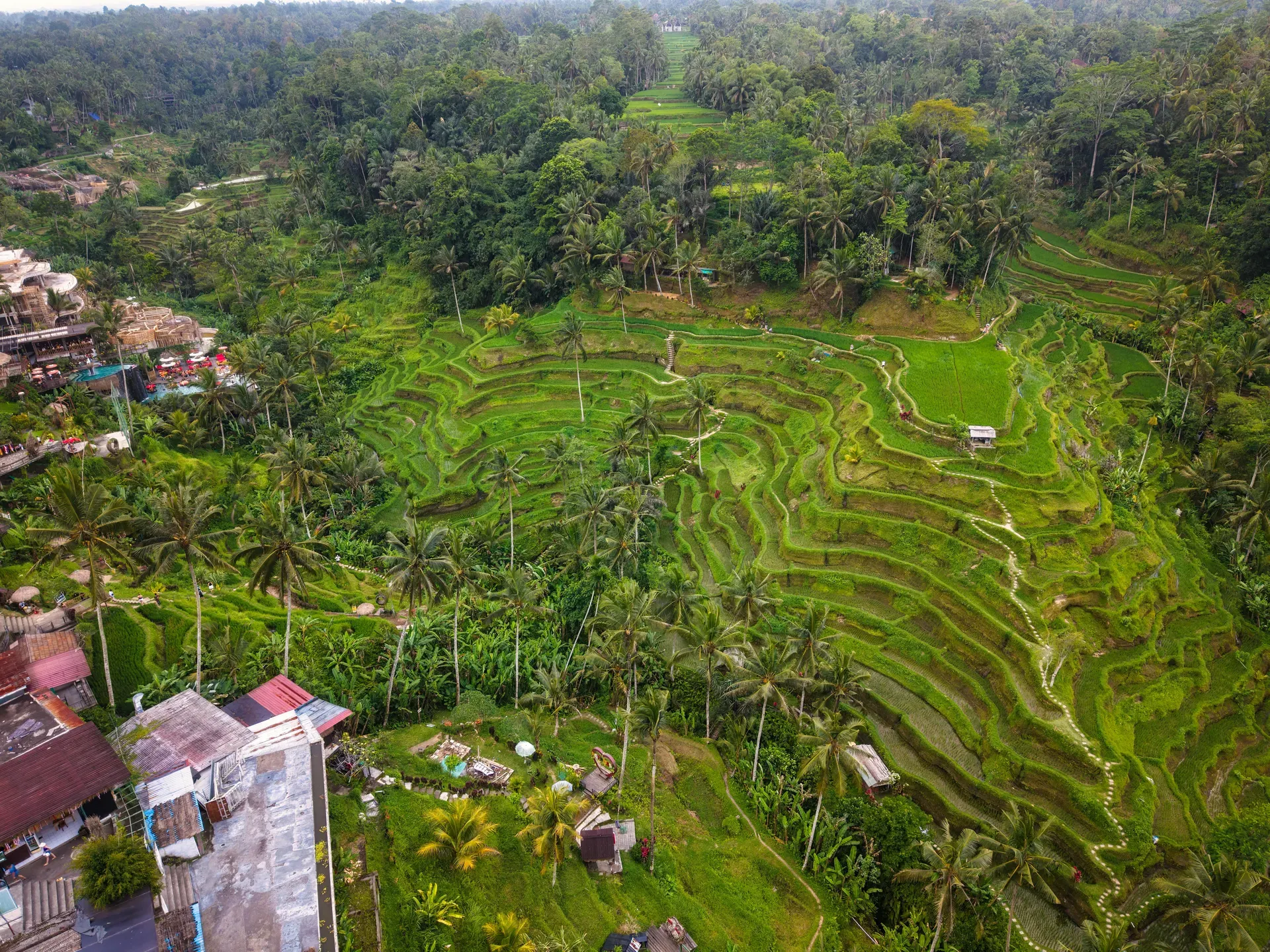
Emerald-green rice paddies drop into a steep valley 9 kilometers north of Ubud. Local farmers cultivate these three-level terraces using an 8th-century irrigation system.
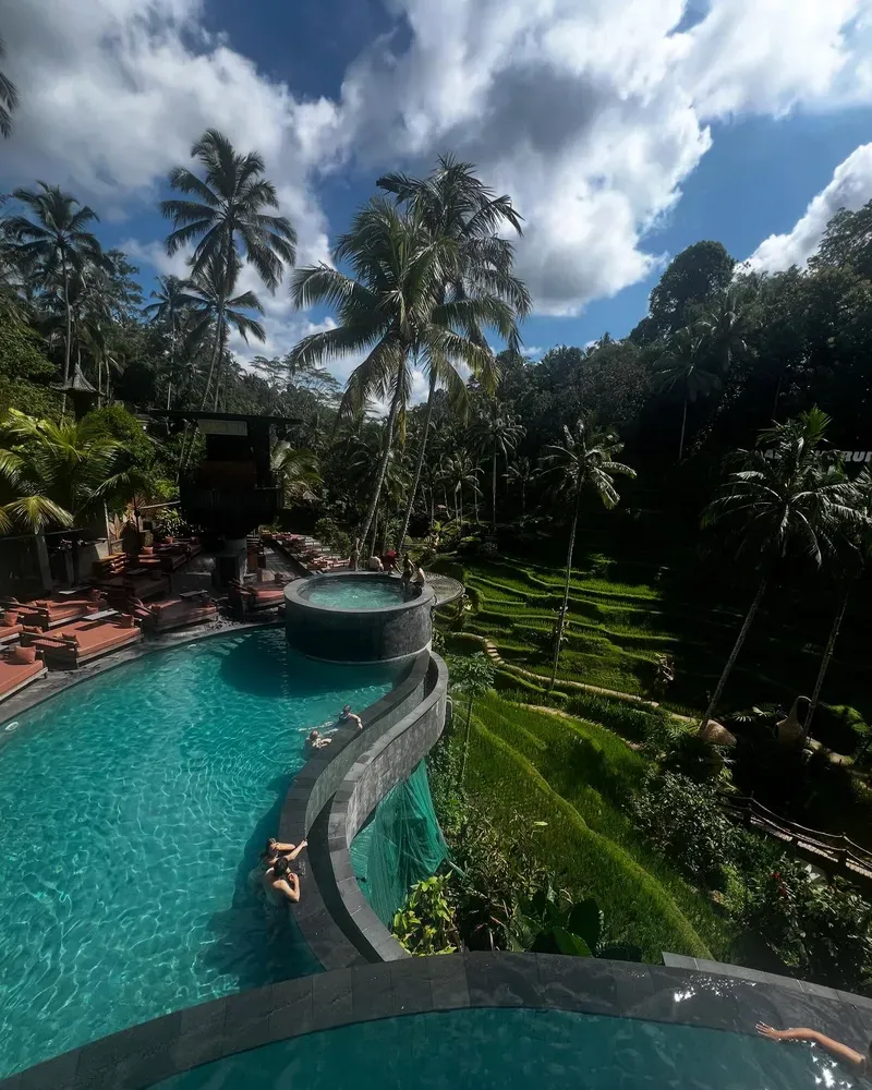
Three main levels of stepped rice paddies drop down the west side of the Ceking valley. Farmers cultivate this agricultural landscape at 600 meters above sea level in central Bali. The primary viewpoint stretches 600 meters along Jalan Raya Tegallalang, looking directly across the steep gorge. Narrow dirt paths connect the active fields, allowing visitors to walk directly through the crops. Infinity pool cafes like Tis Cafe and Cretya Ubud line the upper ridge, offering high-altitude vantage points of the entire complex.
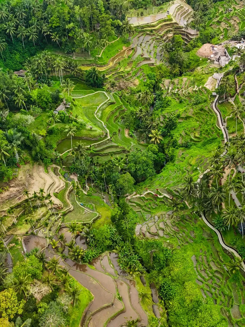
The site operates on the ancient subak irrigation network. Water flows through bamboo pipes and hand-dug channels, distributing moisture evenly across the hillside. This system earned the area a UNESCO World Heritage designation in 2012. You hear the constant trickle of water moving from the upper tiers down to the valley floor. The air grows noticeably hotter and more humid as you descend the 1,000-foot elevation drop into the basin. Tourists share the narrow paths with locals carrying woven baskets of harvested rice.
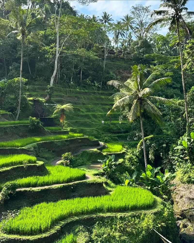
The visual experience changes drastically depending on the month. The rice hits peak green in March, April, September, and October. The fields turn golden-brown just before harvest, and revert to muddy pools during replanting. The clay-like soil turns slick after morning showers. Boots sink into the mud near the water channels. Heavy rain closes the lower valley paths entirely from November to February. Traffic from South Bali can double the standard two-hour drive time during peak hours. Arrive between 07:00 AM and 09:00 AM to beat the tour buses and the midday equatorial heat.
Water management in Bali began with the revered sage Rsi Markandeya in the 8th century. He introduced the subak system to local farmers, establishing a cooperative method of water distribution. Communities carved the first terraces into the Ceking valley using simple hand tools. These early farmers transformed steep, unusable slopes into productive land. The original bladygrass gardens slowly evolved into the complex, multi-level structures present today. The physical labor required to move tons of earth reshaped the entire geography of the Tegallalang district, which now supports a population of over 53,000 people.
Generations of families maintained these specific plots for over 1,000 years. The subak operates independently of the government or royalty. Democratic councils of farmers manage the water flow from the mountain lakes down to the sea. Every farmer receives a fair share of water, regardless of their position on the hillside. This equitable distribution prevented conflicts and ensured consistent harvests through centuries of drought and monsoon seasons. The system proved so resilient that it survived volcanic eruptions, colonial occupations, and modern political shifts without altering its core mechanics.
Global attention shifted to the valley in 2012. UNESCO designated the subak system as a World Heritage Site, recognizing its cultural and agricultural importance. The influx of international visitors altered the local economy. Farmers began setting up small donation booths along the trekking paths. Bamboo bridges appeared over the deepest irrigation channels. Giant swings, charging up to 350,000 IDR per ride, were constructed along the valley rim to capitalize on social media trends.
Today, the terraces function as both a working farm and a major tourist attraction. General entry costs 25,000 IDR, with gates opening at 07:00 AM daily. Concrete cafes line the upper ridge, while the valley floor remains strictly agricultural. Farmers still harvest the rice by hand, beating the stalks to release the grains. Visitors must navigate around active planting and harvesting operations. Avoid the fake ticket sellers in the parking lots and bring 10,000 IDR notes to pay the standard donation fees when crossing private land boundaries.
Eighty meters of stepped earth drop from the roadside ridge down to the river basin. The terraces follow the natural contours of the Ceking valley, creating a massive amphitheater of green and brown. Retaining walls made of packed mud and stone hold back the water in each individual paddy. These walls prevent soil erosion during the heavy monsoon rains from November to February. The sheer scale of the earthworks becomes apparent only when viewed from the valley floor looking upward.
Water enters the system from a single source at the top of the hill. Gravity pulls it through a network of narrow trenches and hollowed-out bamboo pipes. The flow rate is controlled by simple wooden gates that farmers open and close by hand. This precise engineering ensures the lowest paddies receive the same amount of water as the highest ones. The channels also support a secondary ecosystem of frogs, small fish, and aquatic insects that naturally control pests.
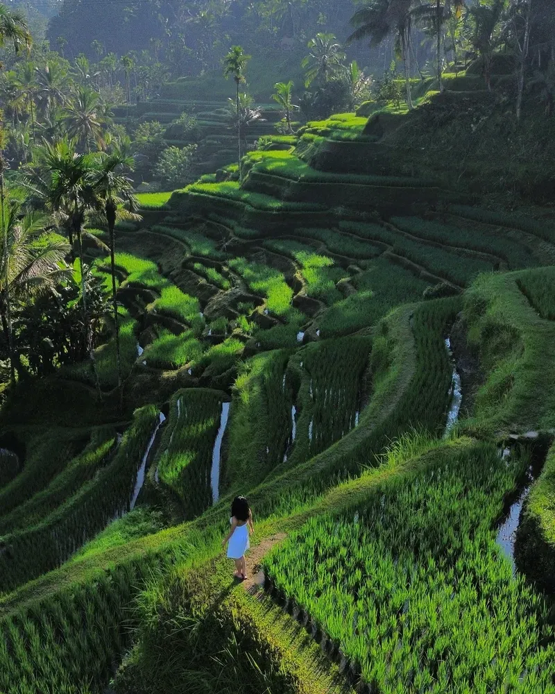
The walking paths measure less than a meter wide. They double as the retaining walls for the rice beds. There are no handrails or safety nets. A misstep sends you knee-deep into the muddy water of the adjacent field. The soil composition is heavy clay, which provides excellent water retention for the crops but creates a slick, treacherous surface for walking. The northern end of the terraces near Abian Desa features wider, flatter paths that see far less foot traffic. Wheelchair users cannot access the steep valley trails but can view the entire complex from the flat roadside sidewalk. Wear shoes with deep treads if you plan to hike the full valley loop.
The subak is a physical manifestation of Tri Hita Karana. This Balinese philosophy demands harmony between the divine, the human world, and nature. Farmers do not view water simply as a resource. They treat it as a sacred gift from Dewi Danu, the goddess of water and lakes. Small shrines built from woven palm leaves and bamboo sit at the corners of the rice fields. These structures mark the spiritual boundaries of each family's plot.
Daily offerings of flowers, rice, and incense are placed at these shrines. The farmers perform specific rituals before planting and harvesting to appease the spirits and ensure a high yield. The subak council meets regularly in the local water temple to coordinate planting schedules and organize religious ceremonies. The nearby Tirta Empul Temple, located just 15 minutes away, serves as a central hub for these purification rituals. Gunung Kawi Sebatu, another tranquil water temple, handles overflow ceremonies away from the main tourist crowds.
This cooperative system binds the community together. A farmer cannot succeed independently; the water must flow through the neighbor's land first. The shared responsibility of maintaining the canals and temples creates a tight-knit social fabric. Visitors walking the paths are stepping through a living religious and social institution. There is no formal dress code required to walk the paths, but aggressive street vendors near the entrance will often try to sell unnecessary sarongs. Do not step on the crops or disturb the small offerings left on the ground.
The subak irrigation system operates entirely on gravity without a single mechanical pump.
The terraces change color drastically, turning golden-brown in April and October just before harvest.
Hiking the full valley loop requires navigating a 1,000-foot elevation change.
The site sits just 30 minutes north of the Ubud Monkey Forest, home to 1,200 macaques.
Drones are permitted in the valley, but operators must fly them away from other visitors.
Farmers collect small 10,000 IDR donations at bamboo bridges to maintain the private paths.
Visitors do not need to wear a sarong here, as the terraces are agricultural land, not a temple.
Arrive between 07:00 AM and 09:00 AM. This avoids the severe midday heat and the large tour buses that fill the narrow paths after 10:00 AM.
The main entry fee is 25,000 IDR, payable in cash. You will also encounter donation points inside the valley where farmers ask for 10,000 IDR to cross their land.
Yes. The paths are steep, narrow, and lack safety railings. You will face a 1,000-foot elevation change on dirt trails that become extremely slippery when wet.
No. The crops turn golden-brown just before the harvests in April and October. The fields are often brown and muddy during the replanting phases.
Prices for the giant swings range from 150,000 IDR to 350,000 IDR per person. These fees are separate from the main terrace entrance ticket.
You can visit from November to February, but heavy rain frequently closes the lower valley paths. The clay soil turns into deep mud, making the steep descents dangerous.
No formal religious dress code applies because it is not a temple. Light, breathable clothing and sturdy walking shoes with good grip are necessary.
No. The official ticket booths and the internal donation points only accept cash in Indonesian Rupiah. Bring small notes.
Wheelchair access is limited to the flat roadside sidewalks and the Abian Desa viewpoint. The actual trekking paths down into the valley have steep stone steps and no ramps.
The terraces are located 9 kilometers north of Ubud Center. A scooter ride takes 20 to 25 minutes straight up Jalan Raya Tegallalang.
Browse verified tours with free cancellation and instant confirmation.
Find Tours